Coldforged: The Continent
Each Thursday this year, I focus on a different aspect of the world I’ve created and played D&D in for over 20 years, in the hopes of cementing enough in place to settle the world in my own mind. This week, I’ve got the map of the continent itself, and am going to be talking a little bit about it.
In the other articles, we’ve started at the very beginning, with the Pillars of the Concept, The Cosmology, and Divine Beings. I’d already gone over the Gods years ago in my Monday Mythology series, So I didn’t talk much about them. This week is behind the creation of the landmass, and its places.
The Landmass
The continent of Tysis, the land on which I’ve run the vast majority of my adventures, was designed to be a land roughly the area of Australia, which is more or less the size of the US. I knew I wanted it to be pretty cold up north, which leads me to a pretty specific set of latitudes in order to hit the arctic circle where I wanted it on the map. This walked me down a number of paths that were then dictated to me, including finding cities in the real world that could represent the relative locations of my created one, building out climate maps, wind and water currents and so on. It was a great look into the inner working of the Island and how it would play out when put into action. So

Oh boy. So this gives me a bit of the jitters because this is one of the only times I’ve shared the physical look of the world I’ve been working on in my head. I love it. You’ve got a pair of bays, a giant swamp, a number of Mountian ranges and some islands off to the west. There is a huge ice sheet in the north, some great forests and a bit of open land here and there. Offshore Islands abound, though I’m sure there are more to be discovered. What it really put into perspective, though, was the size of my continent. In order to reach the area that I wanted to with the north, I would stretch some 45 Degrees of latitude – on an Earth-size planet, pretty significant. In order to make my Perfect Map Size work, I needed 75-mile squares. I also had to push the map up the map a little, making the top at around 75 degrees latitude, putting the arctic circle right at the tree line, which is fine and standard in a couple places on earth with strong continental climates, which is what I expect Tysis to be.
Climate and Weather
This tells a bit of the Story, so let’s get just a little deeper in, I have very crudely, made wind and ocean currents here on a copy of the map.
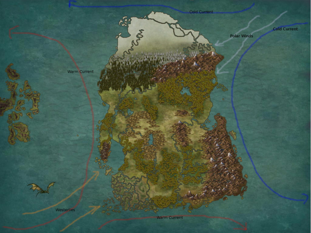
The Warm winds and current from the west
Thankfully, we also have magic in this world, and The Swamp to the south is perpetuated through magic, in addition to the very basic climate concepts I’ve put ahead here. It means that, outside of the swamp and its direct environs, there aren’t a ton of places that escape the brutal winters, though the coast around the bay does tend to experience less of it. Combine all these natural effects with the elemental planes that influence the worlds climate and weather, with a preponderance of cold weather and influence, and we’re in a pretty good spot to start putting out the brutal, cold world that I want to have.
Place Names
Now, let’s take a look at some place names – without relation to nations and countries and people, we will get there eventually, I promise.
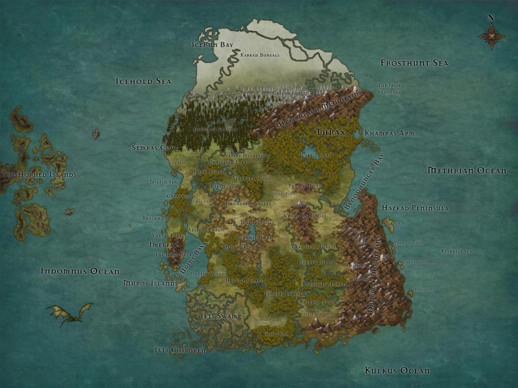
Now. I don’t promise to keep any of these names through the whole process, and if something looks like some sort of glaring innuendo, let me know, but these are pretty close to what I have. Most of the locations and land mass types have the manes I expect them to keep through the process. We’ve named most of the forests, the swamp, all four mountain ranges, the hilly areas, and the lakes. I left the names of the rivers off of this one, because, again, we’ll get there – eventually. This is the most current and accurate map of Tysis that I’ve ever made, and I’m really excited to have it at all on a single map at once.
The Original Countries
Finally, I have the layout of the original countries I had when I created this world some 20 years ago. Its not like this anymore, but the changes since then have been great. First, though, the map.

While it is fairly derivative and basic, do remember that this is a map from the mind of an 8th grader. I knew what I wanted in terms of culture and style, but in terms of a deeper, more varied land, my poor brain just didn’t have it in it. Now, though, its a different world all together. Of the Kingdoms you see on the map, not a single one survives in its original formation. Each of them has retreated, evacuated, been destroyed, consumed or fragmented. New Kingdoms have formed, and the land more accurately represents a strong, gritty fantasy world of tense, divisive politics and the threat of constantly impending war.
While the Continent may have had shaky legs to begin with, its starting to form into something a bit more compeling.
Until next time.