Frolm the Ground Up- Streams, Lakes and swamps
I’ll be playing around with the name a few times, here. The other one didn’t really roll off the tongue. Let me know if you have any ideas.

Over the last few weeks we have looked deeply into Landforms, water and air currents, mountains, and plate tectonics. This week we are going to spend a bit looking into how to naturally create water that seems warranted, accurate and built to be inconspicuous. While many of us don’t look at waterways in the same way a medieval inhabitant would, we still appreciate it in terms of its quantity and usefulness.
Rivers and Streams
Water. Its a simple commodity, covering 70% or more of the earth at any one given time. You’re going to have to make the decision on whether or not that remains the same for your world or not. I suggest that it does, simply to make sure that the assumptions we have made about our world, and our science, stand true but you can just as easily assume that its not so and adjust your weather and water patters to collude correctly. Most of the water, copious that it is, is locked up in useless saltwater or trapped in the sky in both clouds and vapor. Only a very, very small portion of the water in any given world is going to be useful, so we have to make the best of what we have.
The first, and most obvious, are rivers, streams and other waterways. There are a million ways you can say it, but its always the same: Flowing water, heading from its headwaters in the mountains to the sea. It seems elementary, but it bears stating obviously: Water flows downhill. This is something you really have to keep conscious of as you design your rivers. You are always going to have one end that is of a greater elevation than the other, and your going to be paying discreet attention to where you are pulling the water too. Other rivers in the same general area are going to flow towards the same general spot on the map, as it has already been deemed the lower of the elevations in the area. Where two rivers or waterways are flowing, and terminating, in opposite directions you are going to want to give a good reason why. Often this is a highland area, mountain range or plateau that separates the two areas as to form distinct geographical areas. there has to be a geological or magical cause for it.
You’ll also have to worry about rivers meandering. All rivers, hell all waterways, will do this. Meanders are those bends in a river that seem to be caused for no reason – the land is flat, or at least the riverbed, and it seems as if the water should just flow in a straight line. Instead, the river forms massive bends and land salients. This is an effect of the water from one side of the river flowing faster than the other. That faster side will chew away at the river bed, forming the outside of the curve, eating away at the rivers banks. The inside, slower and less violent, will deposit sediment from the outside of the bend inside, creating the salient.

What this means to us, is that rivers will almost never be a simple wiggly line unless they are being kept that way. Instead, waterways are going to wander, meander and make their way across the land in a generally disorganized and unintentional way. Be careful when drawing your rivers, you don’t want to make them too straight!
Lakes
Lakes, thankfully, are fairly simple affairs. Lakes, ponds, and all other bodies of water are simply basins in the land filled by water, either running or precipitated. They are everywhere. Thousands and thousands of them. Some of them smaller than can really be revealed on a large scale map, but every large scale map should have more than a few. I have found, though, that they are one of the few land features I have a very hard time really fitting in, as they seem to just be splattered everywhere, and I’m just not that random. While I can create lakes in mountains and other high areas, its the low lying lands that I have the most problem with, as they always seem simply stuck in after I’m done with all the other features, which isn’t exactly incorrect.
What I’ve found the most applicable is to remember what formed the basins to begin with. Often, they are formed by the same forces as mountains – volcanism and plate tectonics. Volcanoes will erupt and leave behind bowl shaped basins in the earth, which will over time fill with water and either drain down the remains of the mountain or they will become saline lakes high in the mountains. Sometimes, though, they will also erupt so violently that they leave behind massive craters in the land that too fill with water, often from rivers that slowly make their way over to the low lying area. This area will then fill with water and start draining either into the lower aquifer or simply escape out the side.
Both of these ways leave fairly round lakes in hilly, once volcanicly active. In other places, the Glaciers scoured the land deep enough to form divots and depressions that filled with melting glacier water once the offending glaciers receded, leaving cool, clear lakes behind. These are especially exemplified in Minnesota and the Finger lakes region of NY, where hundreds of lakes lie across the land, a testament to the awesome power of glacial erosion. These lakes tend to be bizarrely shaped, having been forced into low lying areas under sometimes miles of ice , they follow the contours of valleys often seeming to sprout mountains from either side.
Dams, both natural and artificial, can cause lakes to be created. These generally tend to be created near mountainous areas, as they are the ones that are more likely to have tons of earth and rock available in order to be able to slide down and block a whole river, stream or other water source and cause it to overflow into the low lying area surrounding the river. These lakes tend to be broad, flat, and shallow, having once been the simple floodplain, though they can get extremely deep if the blocking event is large or wide enough. Beavers, too, can create these same type of lakes, which are havens for plenty of creatures of the forest.
Swamps and Deltas
The last water effect I want to mention is the swamps. Where both rivers and lakes are difficult to place correctly, with a lot of factors to take into account in order to give them the right feel, Swamps and deltas have but two: Lowland, and water. These two areas often mean that swamps surround the areas we have been talking about, creating areas of overflow and absorption of excess rain or melt water in times of inundation. The distinct difference between swamps and shallow ponds is that they are wooded, often with hammocks, sometimes large, of actually passable land that bears water resistant trees, shrubs and other plants. These hummocks and the land they protect enable some animals, plants and even humans to live in swamps that are otherwise submerged for the majority of the year.
When your looking at your map, and the lands where you’d expect swamps, look for bends, bows and curves in the river that you think would be in a forested region or area that could be covered, in great rains and under frequent situations, by water. These are your prime areas to put a natural swamp. Having them in the middle of nowhere, with no precipitating water body nearby makes little sense and will often pull characters unknowingly out of the game.
Deltas are similar, in that they are often swamps, often found at the end of rivers and other bodies of water, except for the fact that they are at the mouth of a river, where it splits into a myriad of different rivers and streams as it approaches the ocean or sea. These fans of rivers tend to flood often, creating great swamps and dangerous areas, full of deep drops into thick mud and fast flowing channels of water hidden among the trees. Deltas often are brackish water, mixing salt and sea, and creating an interesting and unique.
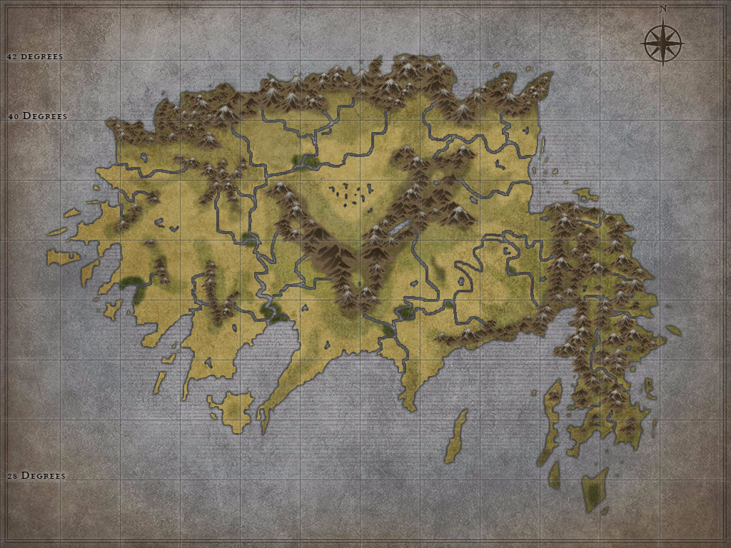
Map.
Given all that, I’ve updated the map. I’m still trying to build in some lakes – I have one! – but I think its coming across nicely. I might have to adjust the quantity of rivers. It both seems like to many and too few, which means I am doing something wrong.
Well, I hope that helps setting up the land you have for streams, lakes, and other water formations. Next week, we’ll take a look at some vegetation, and why and where it goes within a given map.